Planning a journey involves more than just choosing a destination; a real challenge often lies in efficiently crossing borders. Avoid long waits at the borders with this detailed guide to find out which crossings are best for avoiding crowds in the 2026 season.
In the text, you will find a detailed overview of all key routes from Serbia to neighboring countries:
- Main and alternative border crossings
- Exact working hours of the crossings
- Map location to help you calculate your distance immediately
Whether you are planning or already on the road, this guide contains useful information for you and will save yout time.
You can check the border status in two ways while on your way to the crossing:
- Check Google Maps for any delays (you will see columns and delays marked in orange or red).
- Monitor the situation through live cameras. Note that cameras are only available at major crossings. For alternative crossings, use Google Maps.
Both options, both tools, provide information with a slight delay of up to 15-20 minutes sometimes. We advise you to start monitoring the situation an hour or two before approaching the border.
All border crossings from Serbia by travel routes
Route 1: Serbia – North Macedonia
Main crossing: Preševo - Tabanovce
- Live cameras
- Working hours: 00–24h
- Frequency: Busiest crossing, especially on weekends and during the season
- Advantage: Direct connection to the highway
- Drawback: Frequent delays and bottleneck during peak hours
- Navigation on Google Maps
Alternative: Prohor Pčinjski - Pelince
- Working hours: 00–24h
- Live camera: No camera available
- Characteristics: Less crowded, but narrower road with more curves
- Location: Turn at Vranje towards Prohor Pčinjski Monastery
- Navigation on Google Maps
Tip: If the waiting time at Preševo exceeds 90 minutes, this alternative can often save you more than an hour, but be sure to check Google Maps for traffic.
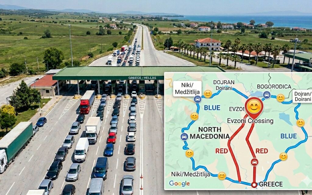
Route 2: North Macedonia – Greece
As most of our tourists travel to Greece for the sea, we have also added these crossings.
Main crossing: Bogorodica - Evzoni
- Live cameras
- Working hours: 00–24h
- Frequency: Extremely high
- Peak crowds: Early morning hours and tourist shifts
- Navigation on Google Maps
Alternative 1: Dojran - Doirani
- Working hours: 00–24h
- Live camera: No camera available
- Location: Turn at Valandovo. Often significantly less crowded than Evzoni.
- Advantage: No freight traffic (trucks)
- Detailed guide: Route to Greece via Dojran – experiences and route
- Navigation on Google Maps
For Northern Greece (Tasos, Kavala, Asprovalta, but also Sithonia and Athos), Dojran is often the most efficient option. Tip: Check Google Maps to see the situation before turning towards the crossing. Many of our tourists “time” their crossing at Dojran early in the morning (before 7 am) to avoid crowds both at the border and on the way to the sea. (By 10 am, you can already dive into the sea).
Alternative 2: Medžitlija - Niki
- Working hours: 00–24h
- Live camera: No camera available
- Location: Near Bitola. The most practical option for those heading to Lefkada, Corfu, and the Epirus region.
- Detailed guide: Route to the Ionian coast through the Niki crossing
- Navigation on Google Maps
Route 3: North Macedonia – Bulgaria
Our people usually use these crossings when vacationing in the Kavala, Thassos, or Asprovalta region and want to pass through Bulgaria (usually for cheaper fuel or a rest in Bansko).
Main crossing: Deve Bair - Gjueševo
- Working hours: 00–24h
- Live camera: No camera available
- Location: on the Kumanovo - Kriva Palanka road. The main route to Sofia. It takes an hour and fifteen minutes from Kumanovo to the crossing.
- Characteristics: The largest crossing on this route. The road has been significantly reconstructed from the Macedonian side (third lane on ascents), making it easier for trucks and you.
- Location on Google Maps
Alternative 1: Delčevo – Stanke Lisičkovo
- Working hours: 00–24h
- Live camera: No camera available
- Location: Connects the Macedonian town of Delčevo with the Bulgarian town of Blagoevgrad.
- Exit: Turn towards Delčevo at Kumanovo. The road takes about 2 hours.
- Characteristics: Excellent option if you want to connect directly to the Bulgarian highway (Struma) leading to Greece. The crossing is smaller, often with no major delays.
- Location on Google Maps
Alternative 2: Novo Selo – Zlatarevo
- Working hours: 00–24h
- Live camera: No camera available
- Location: Near Strumica.
- Exit: at Kumanovo, take the road towards Boljevac.
- Characteristics: The road passes through beautiful landscapes but has many curves. Plan your time as the drive is slower. Read more about this route.
- Location on Google Maps
4. Route: Serbia – Bulgaria
Main Crossing: Gradina - Kalotina
- Live Cameras
- Opening hours: 00–24h
- Frequency: High due to transit traffic towards Turkey
- Characteristics: The border crossing has separate lanes for EU and non-EU (All passports).
- Detailed route description: Driving to Greece via Bulgaria
- Google Maps Navigation
Alternative 1: Strezimirovci (Vlasina)
- Opening hours: 00–24h
- Live cameras: No cameras available
- Location: Near Surdulica and Vlasina Lake.
- Characteristics: Main road via Vlasina Lake. An excellent option for those who want to avoid crowds and enjoy nature. Plan more time for this route.
- Detailed guide: Route to Greece via Vlasina Lake and Bulgaria
- Google Maps Navigation (enter your location)
Alternative 2: Vrška Čuka
- Opening hours: 00–24h
- Location: Near Zaječar.
- Exit: At Paraćin, take the road towards Boljevac.
- Recommended for: Travelers from eastern Serbia or those who want to “cut through” via Vidin towards the Sofia highway.
- Google Maps Navigation
Alternative 3: Mokranje – Bregovo
- Opening hours: 00–24h
- Location: Near Negotin.
- Exit: Exit the highway at Paraćin and follow the direction for Negotin.
- Characteristics: The northernmost crossing to Bulgaria. Plan more time as there are main roads from Paraćin to Sofia.
- Google Maps Navigation
Alternative 4: Ribarci – Oltomanci
- Opening hours: 00–24h
- Location: Near Bosilegrad.
- Exit: Exit at Vladičin Han and follow the road to Bosilegrad. It takes about 2 hours from Han to the border.
- Characteristics: A very quiet crossing, rarely crowded. Use it if you are already in that part of southern Serbia. Plan ahead as the road quality is lower.
- Google Maps Navigation
Important notes for Bulgaria:
- Vignette: As soon as you cross the border, you must purchase an e-vignette. You can buy it at terminals (vending machines) immediately after the crossing or online. Fines are high, and enforcement cameras are everywhere. Detailed info on vignettes.
- Fuel: Petrol and diesel are often cheaper in Bulgaria than in Serbia and Greece, so many travelers fill up their tanks there.
- Crossing between Bulgaria and Greece: The Promahonas crossing has ceased to function as a traditional border crossing and now exists only as a checkpoint. Therefore, once you enter Bulgaria, there is only one control point left before reaching Greece.
Route: Serbia – Croatia
You might not know, but if you love the Adriatic Sea, we have a large offer of accommodation - over 5,000 units, so you can view and book a suitable one here.
Main Crossing: Batrovci - Bajakovo
- Live Cameras
- Opening hours: 00–24h
- Traffic type: All vehicles (passenger and freight).
- Frequency: Very high, especially during holidays and the season. Check Google Maps and cameras for congestion and waiting time estimates.
- Characteristics: Flat, highway. There are separate lanes at the border for EU and non-EU (All passports).
- Google Maps Navigation
Alternative 1: Šid (Tovarnik)
- Opening hours: 00–24h.
- Traffic type: All vehicles (but the terminal is smaller than at Batrovci).
- Frequency: A quick alternative, but crowds can easily form here as well.
- Google Maps Navigation
Smaller, alternative crossings intended only for cars and light vehicles (no freight traffic). Below is an overview table; the main update is that 24-hour opening hours have been introduced, making travel easier.
| Border Crossing | Openinghours | Traffictype | Maplocation |
|---|---|---|---|
| Sot – Principovac | 00–24h | Cars only | Location |
| Ljuba – Principovac | 00–24h | Cars only | Location |
| Bačka Palanka – Ilok | 00–24h | All vehicles* | Location |
| Bogojevo – Erdut | 00–24h | All vehicles | Location |
| Bezdan – Batina | 00–24h | All vehicles | Location |
| Neštin – Ilok | 00–24h | Cars only | Location |
5. Route: Serbia – Hungary (Transit to Central Europe)
This route brings the most changes starting from May 1, 2026, which significantly eases travel towards Vienna, Prague, or Germany as key smaller crossings begin operating non-stop.
Main Crossings:
Horgoš 1 - Röszke
- Opening hours: 00–24h
- Vehicle type: Passenger and freight.
- Characteristics: Main crossing on the highway. Largest capacity, frequent crowds, and longest wait times.
- Google Maps Navigation
Kelebija - Tompa
- Opening hours: 00–24h
- Vehicle type: Passenger and freight.
- Characteristics: Main crossing. Large capacity, but also prone to long wait times.
- Google Maps Navigation
Alternative Smaller Crossings
NEW: As of May 2026, these crossings operate 00–24h (previously open only until 19h)
Alternative 1: Horgoš 2 - Röszke 2
- Opening hours: 00–24h
- Location: Located on the old road, parallel to the highway.
- Vehicle type: Cars only, no freight traffic.
- Characteristics: Ideal for avoiding crowds at the main terminal.
- Google Maps Navigation
Alternative 2: Bački Vinogradi - Ásotthalom
- Opening hours: 00–24h
- Location: Located on the old road, parallel to the highway.
- Vehicle type: Cars only, no freight traffic.
- Characteristics: Excellent crossing if you are coming from the direction of Subotica or Palić.
- Google Maps Navigation
Alternative 3: Bački Breg - Hercegszántó
- Opening hours: 00–24h
- Location: Located on the old road, parallel to the highway.
- Vehicle type: Passenger and freight traffic up to 3.5t.
- Google Maps Navigation
Other alternative crossings with daytime hours: 07–19h
These crossings are intended exclusively for passenger vehicles and operate only during the day:
| Border Crossing | Opening hours | Map location |
|---|---|---|
| Bajmok | 07–19h | Location |
| Đala | 07–19h | Location |
| Rastina | 07–19h | Location |
| Rabe | 07–19h | Location |
Mobile Internet Tip: As soon as you enter Hungary, you switch to EU roaming rules. If your Serbian package does not cover the EU, a very simple solution is eSIM cards, which allow for affordable navigation and internet throughout the European Union (the Vela package, for example).
4. Route: Romania (Less Crowded)
An ideal route for travelers to western Romania or transit to the north.
- Daytime crossings (07–19h): Nakovo, Vrbica, and Jaša Tomić. These crossings are exclusively for light vehicles (up to 3.5t), guaranteeing a quick passage without truck queues.
- Non-stop (00–24h): Vatin, Kaluđerovo, and Đerdap.
Golden Rules for Safe Travel
- “Live” Status: Before every key highway exit, check the live cameras (all in one place). The situation can change in less than 30 minutes.
- Vignettes: Bulgaria, Hungary, and Romania require electronic vignettes. Buy them online before arriving at the border to avoid queues at sales points.
- Border Lanes: In Bulgaria and Croatia, strictly follow the “All Passports” sign if you do not have EU documents to avoid being sent back to the end of the line.
- Tolls (TAG): In Serbia, the most efficient way to pay is via a TAG device in the Open Balkan system, which allows passage without stopping.
Timely information is just as important as vehicle maintenance. By using alternative crossings and monitoring live cameras, you make your journey significantly more pleasant and efficient. Have a safe trip!


