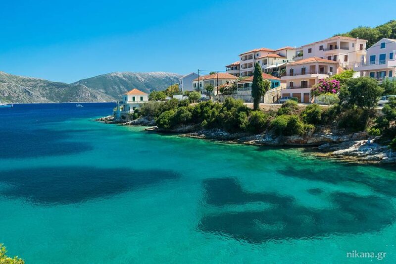
Santorini, one of the most beautiful and visited Greek islands, is known not only for its stunning landscapes and volcanic activity, but also for frequent earthquakes that have shaped its history. Earthquakes on this island are often connected to volcanic activity, and these seismic activities date back centuries.
In this text, we will explore the most significant volcanic eruptions and earthquakes that have hit Santorini, their power, and consequences.
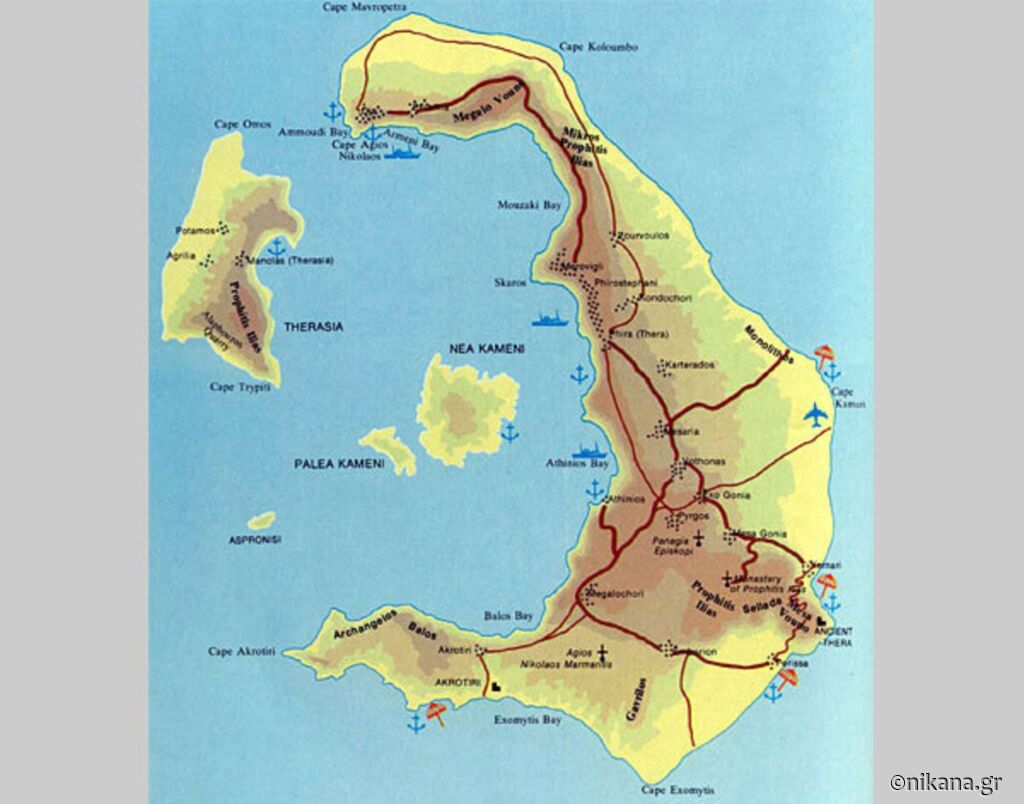
Santorini lies on a special line called a fault, which extends from Santorini to the volcano Columbo. This fault is where the Earth’s plates collide and shift, making the area highly seismic. This line is part of the volcanic “ring of fire,” and it houses the volcano on Santorini and the underwater volcano Columbo, north of it. Due to this geological line, the area is prone to earthquakes and volcanic eruptions.
History of volcanic eruptions on Santorini
The first volcanic eruptions on Santorini occurred on a pre-volcanic island, at the site of today’s Prophet Elias mountain in the southeast of the island. This early landmass was a remnant of a larger mass of metamorphic rocks, as evidenced by the findings of marble and phyllite in that area. Initially, the eruptions consisted of acidic lava, and over time, the island grew, adding new layers of volcanic materials.
Volcanic activity continued with the formation of five volcanoes on the island:
- Peristeria (northern part of the island),
- Simantiri (western part),
- Skaros (northern part),
- Thirassia (west of the main island),
- Central volcano near Akrotiri.
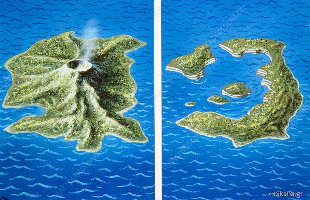
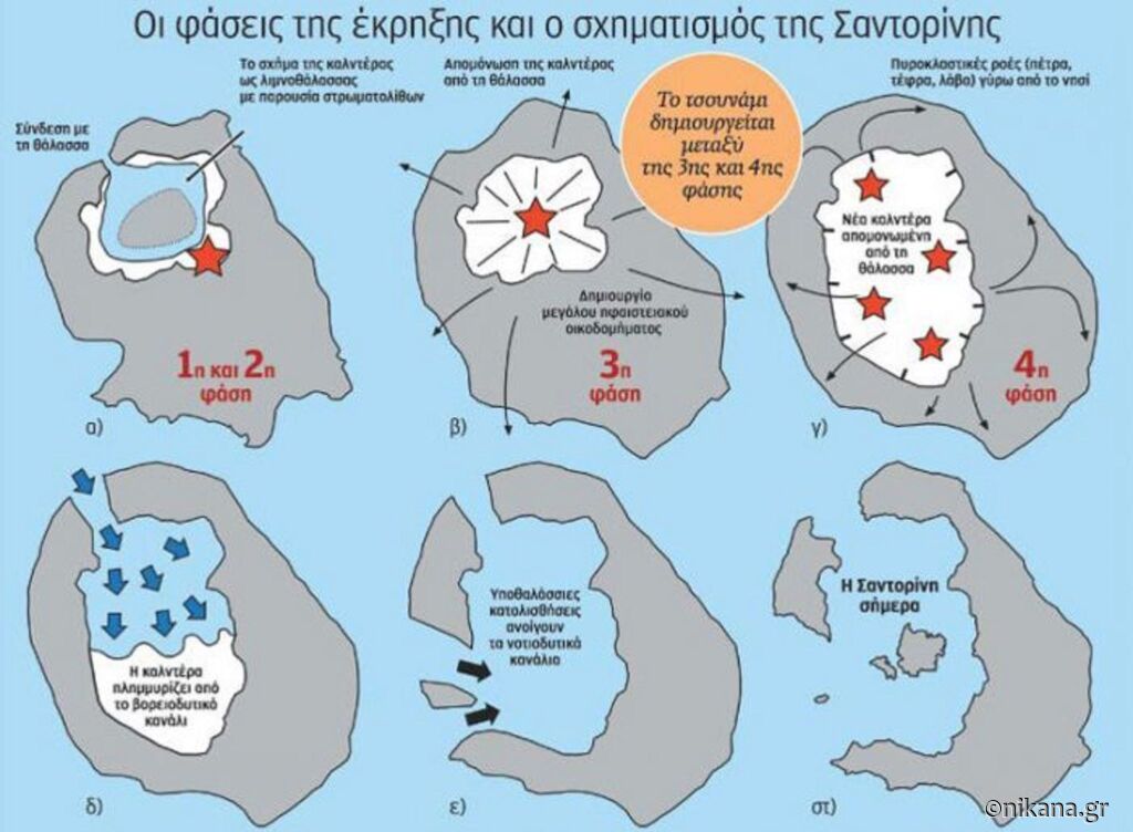
Over thousands of years, these volcanoes merged and shaped the volcanic island of Strongili, which had a height of 600 to 1,000 meters.
Major eruption and the formation of the caldera - destruction of the Minoan civilization
The largest volcanic eruption on Santorini occurred around 1613 BC. This eruption was one of the most powerful in history and is believed to have led to the collapse of the Minoan civilization on Crete. Huge amounts of ash and gases were ejected into the atmosphere, while the central part of the island sank, forming the present-day caldera.
The remains of the former island of Strongili now make up three islands:
- Santorini (Thira),
- Thirassia, and
- Aspronisi.
Volcanic activity in the caldera continued after this cataclysm, leading to the formation of new islands, including Palaia Kameni (197 BC) and Nea Kameni (1707-1711).
Later volcanic eruptions
In recent centuries, the Santorini volcano has remained active, with periodic eruptions:
1650 - Underwater explosion near Columbo, east of the island, caused a tsunami and poisonous gases that killed 40 people. 1866-1870 - Major eruptions led to the growth of Nea Kameni. 1925-1926 - Dafni dome was formed. 1939-1941 - Eight new volcanic domes were formed. 1950 - Last known eruption on Santorini.
The Santorini volcano has not erupted for more than 70 years, but the emission of gases (CO₂, SO₂, H₂S) on Nea Kameni indicates that volcanic activity has not ceased.
Earthquakes on Santorini throughout history - chronology
46 AD Magnitude 6.0 Richter scale (7 on the Mercalli scale). Followed by a volcanic eruption, causing a tsunami in Crete.
1649 - 1650
- In 1649, magnitude 6.8 Richter scale,
- In 1650, magnitude 6.8 R. Intensity VIII (8).
In September 1649, seismic vibrations began to increase, reaching a peak on September 29 when an underground volcanic eruption occurred with a large amount of ash. Consequences:
- A 30-meter tsunami on the western coast of Patmos.
- Earthquake felt as far as Constantinople.
- 40 people lost their lives due to poisonous gases, as well as many animals and birds.
- Domestic animals lost their sight for 8-9 days!
- Volcanic ash reached Asia Minor, covering tree leaves!
- 200 houses collapsed in Thira.
- The sound of the volcanic eruption was heard in Chios (224 km), while
- Kalogeri, a small island between Andros and Chios, was likely destroyed.
1707 Magnitude 6.0 Richter scale, Intensity VI (6) - formation of Nea Kameni.
Detailed information about these earthquakes is provided by the Jesuit traveler Tarijon.
- On May 18, two earthquakes were felt throughout Thira.
- From then on, rocks rose from the sea, and on May 23, lava appeared above the sea.
- In the following days, a small island was formed.
- From July 16, through continuous explosions and smoke, two new islands were formed, Mavronisi and Aspronisi, as the Santorini people named them based on their color.
1707 - 1711
- On September 2, 1707, an earthquake occurred, accompanied by a strong explosion. On September 9, two islands merged, forming Nea Kameni.
- Volcanic activity continued until 1708 according to Perilon, and until 1711 according to others.
An interesting report is from the French traveler La Motreja. He visited Santorini at the end of August 1707. On August 24⁄25, when his ship was off Naxos, he heard thundering like cannons or lightning and rumbling. As the ship approached Santorini, he saw flames rising high along with rocks from the black island: “A heavy smell of sulfur soon reached my nostrils, choking me, I couldn’t even make a sound. Then came the headache, difficulty breathing, nausea. On September 2, an earthquake occurred, accompanied by a terrible explosion. Molten rocks were thrown from the volcano crater…”.
1866-1870 1866 - Magnitude 6.2 Richter scale, houses and churches damaged. January 31, 1866. Magnitude 6.2R. Intensity VIII (8).
After several subsequent aftershocks, a strong earthquake occurred damaging 50 houses and 2 churches. After the main earthquake, the ground began to settle, causing serious damage to buildings on the island. On February 20, strong seismic tremors were felt as far as Chios. The earthquakes lasted until November and were felt as far as Crete. (Sieberg 1932a). Kiriyazopulos (1979) reports that at that time, the islands of Georgios I and Afrosea were formed, while on January 18, a partial sinking of Nea Kameni began. The sea began to roil, coastal houses were crumbling and disappearing, while shipowners tried to save their ships from the boiling sea and the volcano. Earthquakes and volcanic activity lasted until October 15, 1870.
1919 - 1920 1919, April - Magnitude 6.1 Richter scale, earthquakes felt as far as Crete. A very strong earthquake felt as far as Messinia. However, its great focal depth (140 km) did not cause any material damage. October 25, 1919, at 17:10. Magnitude 6.1R. Intensity VII (7). The earthquake caused damage in Fira (Thira town, the main town of Santorini), Oia, and Karterados. It also caused minor damage on Naxos. The main earthquake was also felt in northern Crete and Heraklion. Before the 6.1R earthquake, there were foreshocks, with the largest (4.7R) occurring at 17:03 on the same day. Many aftershocks followed, with the largest also happening on the same day at 17:53:32, with a magnitude of 5.6R. November 15, 1920, at 20:09:43. Magnitude 6R. Intensity VI (6). The earthquake was particularly felt, except in Thira, Naxos, Heraklion, and Melidonia, in northern Crete. However, due to the great focal depth (120 km), no serious damage was caused.
1935 March 18, 08:40:45. Magnitude 6.4R. Intensity V (5). The earthquake was strongly felt in Santorini, and less so in Chania and Sitia. Due to the great focal depth (70 km), no damage was caused.
1956 The strongest earthquake in the modern history of the island, magnitude 7.5 Richter scale, destroyed numerous buildings. Although the earthquake epicenter was near Amorgos, it also caused extensive damage to settlements on Santorini (Oia, Fira, Imerovigli, etc.), as well as Anafi, Ios, Paros, Naxos, Astypalea, Leros, Lipsi, Patmos, and Kalymnos, where a tsunami caused the most severe damage! 53 people died, and 100 were injured. A total of 529 houses were destroyed, 1,482 suffered severe damage, and 1,750 sustained minor damage. The resulting tsunami reached a height of 25 m on the southeastern coast of Amorgos, 20 m on the northwestern coast of Astypalea, and 10 m on Folegandros. The main earthquake was preceded by a 4.9R earthquake on July 8 (13:05), followed by numerous aftershocks, with the largest occurring just 13 minutes after the main earthquake at 03:24, with a magnitude of 6.9R (Papazahos) or 7R (Spiropoulos).
If you want us to recommend accommodation according to your preferences, write to us directly at the email nikana@nikana.gr and you will receive suggestions as quickly as possible.
We are always here to help you explore Greece! Follow us for the latest information, useful tips, and authentic experiences to make your holiday in Greece unforgettable!
We offer over 3,000 accommodations. Choose the one that suits you and your family by clicking HERE.
Follow us on social media where we regularly share exclusive offers, discounts, and special packages for holidays in Greece, as well as information, tips, and useful news. Facebook: Nikana.gr Instagram: @nikana.gr Tiktok: nikana.gr Facebook group: Live from Greece YouTube channel @NikanaTravel Write to us via email: nikana@nikana.gr Visit our website nikana.gr which is the leading source of information about Greece in the Balkans.


